

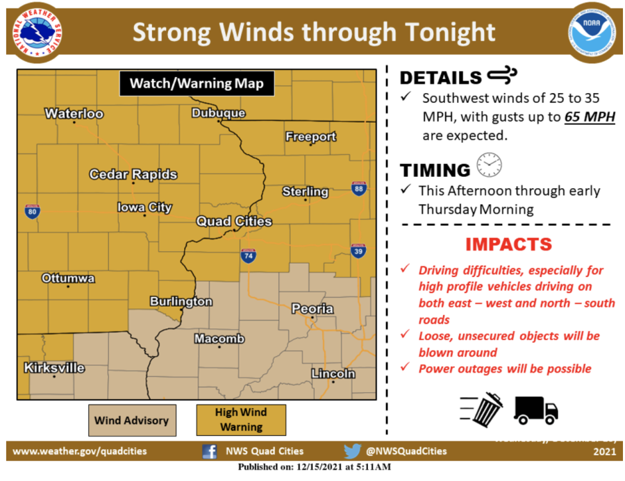
High winds, thunderstorms expected for eastern Iowa Wednesday afternoon
Gusts are expected to reach above 65 miles per hour, and driving will be difficult.
Source: National Weather Service
December 15, 2021
On a December day that broke records for weather in the high 60s and 70s, Iowa is bracing for wind storms expected to reach much of the state Wednesday afternoon.
High winds are expected across most of Iowa Wednesday afternoon and into the evening, and a tornado watch is in effect for much of western, central, and northern Iowa.
The wind speed as of 2 p.m. had reached 38 miles per hour in Iowa City, according to the national weather service. Gusts are expected up to 65 miles per hour or higher later in the afternoon and evening.
The strongest winds are expected to come after 3 p.m. Wednesday and extend into Thursday morning, according to the NWS.
An NWS high wind warning issued Wednesday morning said winds will blow down trees and power lines, and power outages are expected throughout the state. Driving will be difficult and loose objects will likely be blown around.
“People should avoid being outside in forested areas and around trees and branches,” the warning said. “If possible, remain in the lower levels of your home during the windstorm, and avoid windows. Use caution if you must drive.”
Previous graphic updated due to expansion southeastward of the enhanced risk. pic.twitter.com/I4zvJPFFOW
— NWS Quad Cities (@NWSQuadCities) December 15, 2021
Eastern Iowa can also expect thunderstorms Wednesday night. A fast-moving storm will move east over Johnson County this evening, according to the NWS, and it will only impact any given area for less than 30 minutes. A tweet from the Quad City NWS said an isolated tornado cannot be ruled out.